Friday, December 5, 2014

Florida for Christmas and into 2015

We're getting the boat ready to leave our dock on December 9, to head south to meet our daughter and her family in Sarasota on December 20.  Stay tuned!

We're under way.  I dropped the lines at 0900 Tuesday morning with our friend Bob on board to help me get the boat to Delegal Creek Marina, at the south end of Skidaway Island near Savannah.

Claria had a commitment at Church, so when done, drove Bob's car to Delegal Creek Marina and Bob drove back home.  Bob's wife Janet rode down with Claria and the plan was to have dinner on the boat, but the day got late and Bob and Janet needed to get home to relieve the doggie babysitter, so we missed out on dinner.  We had a stiff breeze from the NW and as we crossed Port Royal sound with the wind apposing the tidal current, we gave the boat a genuine salt water bath!

We'll be in delivery mode for the next 9 days, needing to average 65 miles per day to get to Sarasota by Friday, December 19 so we can pick up the Johanson clan at the Tampa airport Saturday morning, December 20.

Wednesday we continued south to an anchorage just north of St. Simons, GA.  Uneventful day.
 
Thursday we went into Brunswick to fuel up at $2.65 per gallon, including tax.  Spent the night at the free dock at Jim King Park on Sisters Creek just north of where the ICW crosses the St. Johns River.  This is a new dock with room for 4 to 6 boats depending on size.  Four boats were on the dock Thursday night.
 
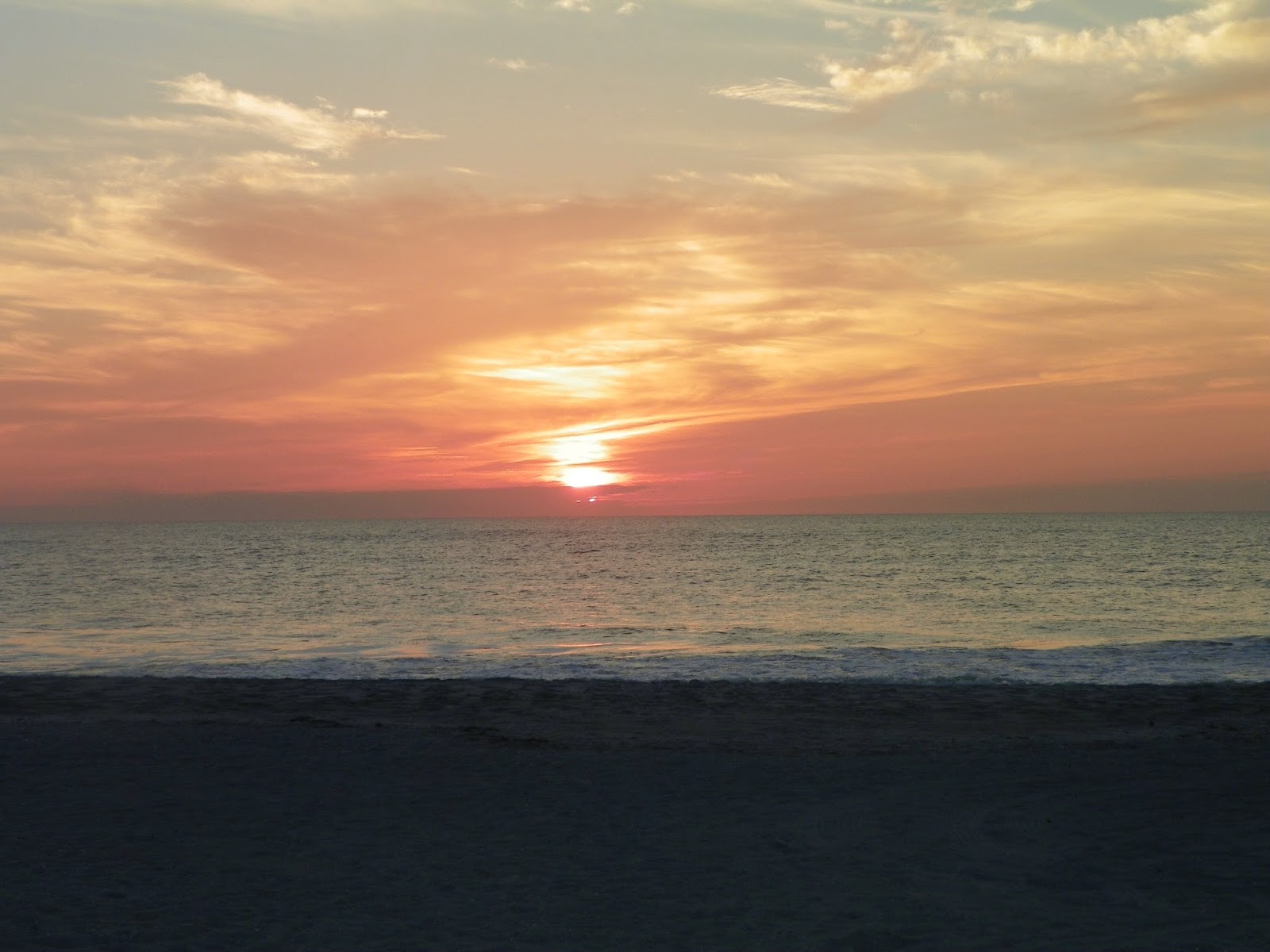
Friday we got to Marineland Marina, south of St. Augustine, one of our favorite stops, across highway A1A from Marineland Dolphin Park.  We were invited to join Looper friends Jim and Pam on Silver Boots for a wonderful dinner.  Here is a picture of ODYSSEE against the setting sun.   
 
 
We've been on a roll since my last post.  After leaving Marineland, we traveled 81 miles to an anchorage just north of Titusville.  In the morning the sun rose over the VAB at Complex 39 at Cape Canaveral. 

On Sunday we put in another pretty good day and got to one of our favorite anchorages north of Vero Beach.  On Monday, one of our missions was to find a Post Office to mail 100+ Christmas cards and a package.  On our way through Stuart we went into Frazer Creek to a public park with a day dock.  Both Skipper Bob and our Florida Cruising guide suggested you anchor your boat and take a dingy into this park, but ODYSSEE doesn't draw much water, why not just take ODYSSEE into this day dock, postings on Active Captain suggested it's possible. and it was.  At least 6.5' of water all the way in and a channel that is 60'wide, wide enough to turn a 48' OAL length boat around!  The Post Office was about a 5 block walk.  Back on the boat we went another 8 miles up the St. Lucie River to the St. Lucie Lock, locked through, and anchored for the night just above the lock at 6:50 PM.

Today, Tuesday December 16, we continued on the Okeechobee Waterway


 and are at Moore Haven, tied to the canal wall.  We met two other boaters here, and after some sundowners, decided to go to the only restaurant in town, a Mexican place.  Well, after a 5 block walk into town, the restaurant was closed, so back tom the boats and pot luck on ODYSSEE, the only boat with a table large enough to seat 6 people.

Wednesday we were up and off the dock by 7:35, anticipating a long day to get west of Ft. Myers.  We had two locks to go through and experience has taught us that that doesn't always go so smooth.  As we approached the Ortona Lock, I called the lockmaster on the radio when we were 20 minutes out to let him know we were approaching west bound. Saw this Eagle pair along the canal.


We'd been listening to the locking activity on the radio and all was going smooth.  We announced our arrival to the lockmaster and were told the lock was down for a gearbox repair at it may be a two hour wait.  We put the anchor down and waited, using this time to call down river and shop for a good fuel price, realizing that this delay would shorten our day and jeopardize how far we would get.  Good news, after a half hour wait, things were fixed and we locked through.  No problems at the Franklin Lock, breezed through.  When shopping for a good fuel price we found some for $3.04 per gallon at The Marina at Cape Harbour at the far west end of Cape Coral.  Made arrangements to go in and spend the night and fuel up Thursday morning.  We arrived as the sun was going down, and had to lock through a small water control lock, 65' X 19', to get into the marina.  Never a dull moment!

The marina opened at 7:30, and we wanted to get fueled as soon as possible so we could get to Sarasota.  Called the marina office at 7:30, no answer, again at 7:35, no answer, finally at 7:40 the dock master answered.  "Where is your fuel dock" I asked, "on the outside of the lock" he replied.


So, back through the water control lock, and finally, 252 gallons of fuel.  We lost an hour in this process!    Finally underway at 8:40, we had 79 miles to go to get to Sarasota, and with all the "slow, NO WAKE zones" it was going to be tough to do before dark.  And in fact we didn't, came into Marina Jack at about 6:15 and went into our assigned slip bow first in the dark.  After we were in, realized the finger pier was too short to get off the boat, so backed out, turned around, and backed in, without hitting anything, in the dark!  We were finally tied up at 6:35.

Spent Friday doing some laundry, provisioning, and getting things ready for our Michigan family to arrive.  Saturday morning Chuck drove a rented mini-van to the Tampa airport to pick everybody up.  They were a little late, and then there were two accidents that held us up on the way back, so it was almost 1:00 when we got back to the boat.  These overdressed visitors were ready to change into shorts!


ODYSSEE is poised to head out tomorrow for a planned stop at Stump Pass State Park Sunday night, then a night at Boca Grande, arriving in Ft. Myers Beach on Tuesday.

Sunday morning we were pumped out, watered up, and under way by 11:00.  It didn't take the Michigan women to find a comfortable place on the bow seat and give the sunshine a thumbs up!


We stopped at POP's for lunch in Venice, and then continued on to Stump Pass to anchor for the night.

Monday morning the sun was out, and so were the pelicans, both white and gray, looking for breakfast.


Mary and Elisabeth decided to take a kayak ride to the south where we would meet them and pick them up with ODYSSEE.  Peter took the dingy to make sure nobody got in any trouble


Our planned destination was Boca Grande and an afternoon on the beach.  Nobody was having any fun!

 
We cast off at 11:00 this morning for a 36 mile run to Ft. Myers Beach.  It was another nice day, a little breezy, but we ran inside down Pine Island Sound, so waves were not a problem.
 
Three generations enjoying the ride,

 
Captain Pete at the helm.
 
We've arrived at Ft. Myers Beach and will be here at least two nights.  Claria is making her traditional Christmas Eve dinner, Swedish Meat Balls with all the fixings.  We will have 12 for dinner and then go the Chapel by the Sea, a lovely Presbyterian Church on the beach.
 
Spent Christmas morning opening all the presents Santa had left on the boat.  It's amazing how he knows where we are each Christmas Eve!  A short walk on the Ft. Myers Beach beach, and then off to Tween Waters Resort and Marina on Captiva.  It was another nice day in the mid seventy's.  Once ODYSSEE was safely tied to the dock the troops
walked over to the Captiva beach and stayed to see the sunset.


From Tween Waters we moved to the Edison Ford Marina.  This was the former Royal Palm Yacht Club in Fort Myers, and it was bought by the Pinchers Restaurant group and is now a marina open to the public.  They aren't quite functioning up to par yet, but they are working on it.  It was our intent to rent a car and go down to Naples on Sunday and then deliver the Johanson bunch to the airport early Monday morning.  There were no cars to rent on Saturday afternoon, except from Expedia, Priceline, or one of these discount outlets, and they all wanted $250.00 per day.  I called three rental companies directly at the airport and they confirmed I would not get a car if I came to the airport, they were all reserved.  For those of you who rent cars, you know you don't pay for them until you pick them up, and the rental companies don't even take a credit card number when you make your reservation, so it's easy to walk away from a reservation.  So, I think when supply gets low, the discount outlets reserve what is left and then try to get exorbitant prices for them, and if they don't rent them, just cancel them.  What do you want to bet there were several cars unused at the airport!  So, in desperation I call a good boating friend up in Illinois who keeps a car in Florida.  Walla, his car was in Fort Myers in storage and the key for his storage unit available at the storage office, with the car key in the car.  He bailed me out, THANKS PHIL! 
 
It's now Monday morning, the kids are on an airplane heading home, and we are cleaning up the boat.  Our washer/dryer decided to quit, so we will be making a trip to a Laundromat.  We also have a box of stuff to ship north so a UPS Store is also on our list.
 
It's New Years Eve and we have everything fixed, so we are heading south tomorrow towards Everglades National Park.  We will be on the hook and in the wilderness up the Little Shark River for the next 4 days or so, getting into Flamingo about next Tuesday.  We should find internet somewhere in the park so can update on our trip up the Little Shark River and add some pictures of the wilderness.  You can only do the Little Shark in a boat, ODYSSEE may be considered a little big for the upper end of the river, we'll see how far we get.
 
I have created a separate POST for Everglades National Park.


Wednesday, January 1, 2014

2014 Trip to Florida

It's January 1, 2014, and we're getting ODYSSEE ready to head south for a short trip to an AGLCA Golden Looper Reunion at Hutchinson Island Resort and Marina on January 15-16.  Plan is to drop the lines at Distant Island Yacht Club at 0600 on January 6, with the hopes that the seas on the outside will be acceptable so we can run outside and get to the south end of Georgia at the end of the first day.

We left our dock on Monday, January 6, with the threat of a strong cold front approaching.  Two days ago it started looking marginal for a comfortable run out side, so plan B is to go to Delagal Creek Marina at the south end of Skidaway Island at MM600, 61 miles from our dock.   We didn't make our goal of dropping the lines at 0600, but at 0745 we headed south down Chowan creek with a light SW breeze on our nose.  Halfway to the southern point of Parris Island, 40 minutes off the dock, the wind turned west and started to blow. The cold front had arrived.  By the time we turned the corner to the west across Port Royal Sound towards Hilton Head Island, with the wind and tidal current going opposite directions, we had 4-6' waves on our bow.  Not only was the wind blowing, the temperature was dropping.  Once again we were glad to be driving under a hard top with a windshield with wipers. 

After crossing the Savannah River, we turned left off the ICW on St. Augustine Creek to Turner Creek, joining back up with the ICW where Skidaway River leaves the Wilmington River.  We arrived at Delagal Creek Marina where we were greeted by Billy, the best dock master on the east coast.   Forecast is for 21 degrees tonight, nice to be plugged in.  ODYSSEE has two electric heaters and two reverse cycle AC units, so we will be comfortable.

We left the dock at Delagal at 0850 Tuesday morning.  Low tide was 0.00' at 0700, so for those boaters reading this post know the potential problem of getting over "the bump" at the end of their channel should be literally "touch and go".  We found by hugging the green side between G5 and G3 that we had no less than5.5', or 2' under our keel.  So at 0.00' water, there is at least 4.5' of water in that channel.  The wind was still blowing stiff from the NW, and as we crossed over to Hells Gate, we splashed several waves onto the windshield in front of the drive station, which quickly froze.  Are we having fun yet!  We made it to Jekyll Harbor Marina at 1730, just as the sun was going down, an 84 mile day. The dock hands were a couple of idiots, trying to tell Claria which line to throw first.  The tide was going out and the wind blowing NNW.  We came in starboard too, with the bow facing N into the tide.  I was trying to reduce the effect of the wind blowing us into the dock by holding the bow out to use the current on the keel to counter act the wind.  Claria threw him a bow line and told him to just "hold it" while she went aft to the mid cleat to give him the spring line.  No, he didn't "hold it", he pulled on it and pulled the bow in, and as soon as it grabbed the tidal current the bow came slamming in into the dock in front of the front bumper.  IDIOTS!  Then they wanted to move as back to get us closer to the power pole, and sinched us up with a large piling right at the door opening so we couldn't get out of the boat.  So now we try to move the boat forward about three feet, they ask me to power it forward, but hadn't untied the stern, so I didn't go anywhere.  IDIOTS!  They offered to help us off in the morning if we call them on the radio, I don't think so!

Wednesday morning we pulled off the dock at 0855 without any help.  This shrimp boat owner is either having a great day, if he wanted to clean his bottom, or a really bad day if he didn't.  We took this picture at dead low tide, he should be able to float off at high tide.

As we entered Cumberland Sound near the St. Mary's, GA submarine base, the coast guard hailed us on the radio to request a boarding to run a safety check.  These events always start out a little confrontational, but within a few minutes the Coasties realized they were on a boat will equipped that exceeded all coast guard safety requirements, so any initial anxiety was soon relaxed, and the rest of their time on the boat was very pleasant.  Fueled up in Fernandina Beach, but the needle point store was closed, so kept right on going to the free dock at Jacksonville at MM739.  The weather was warmer but deteriorated into showers as we approached Jacksonville.

Left the free dock on Thursday at 0910 in showers for an easy 39 mile ride to St. Augustine.  The local boaters have their monthly cocktail party on the second Thursday, so we were invited to join them.  We were joined by Doug on Cot'ntop who was in the slip next to us.

Friday morning we woke up to fog.  Finally left at 1000 for an easy ride to Marineland, 20 miles down the waterway.  Cot'ntop tagged along with us. The small marina is a very pleasant stop, operated by two great guys who also run an eco tour business through the nature preserve to the west of the ICW.  As we drove in, we were surprised to see Lance and Louise there with their boat.  They have been here since August.  Last winter we met them in Islemorada down in the Keys.  We had dinner with looper friends who live just south of Marineland.  We finally where able to wear shorts today, yah!

Saturday we traveled to New Smyrna Beach and stayed at the free town dock.  Cot'ntop followed and we able to get both of us on the free dock.  Had dinner in town and just got back to the boat before the sky opened up with a torrential downpour.

Sunday was a long ride through the wilds south of New Smyrna into the northern end of Indian River, past the old Complex 39 Vertical Assembly Building at Cape Canaveral and on to Cocoa, where again we stayed at the free town dock.  Cot'ntop followed, but anchored for the night. 

On Monday morning, before departing, Chuck went to Travis Hardware to rebuild our tire pump and Claria went to the bakery for some goodies.  With jobs completed, we cast off at 0900 for a days run to Vero Beach.  Again Cot'ntop tagged along.  At about 1400, Cot'ntop called on the radio to warm me there was a "hot one coming up my transom".  It was a charter fishing boat returning from a days fishing, and yes he was really coming.  The channel was narrow and turning slightly to the right, I had a 19' small sailboat in front of me taking down his sails, and a Florida Law Enforcement boat coming at me.  I'm sure the charter boat could not see the Law Enforcement boat.  I had slowed down to give the sailboat time to get under control.  As the charter boat approached he slowed some, but never dropped off plane, making an even bigger wake, the sailboat turned to the right out of the channel, the Law Enforcement boat came by, and I did a hard left turn, with my port engine in reverse, to get my bow into the 4'+ wake the fishing boat was making.  I succeeded, the Law Enforcement boat saw the whole incident, did a 180 and chased down the fishing boat which was now back up and running at 30 +/- MPH.  Good news is the charter boat got stopped, and I'm sure got a good ticket, he was retained for a good 30 minutes.  He turned into a marina before he passed us again.  We got to a favorite anchorage just north of Vero Beach and had our anchor set by 1530.

On Tuesday morning we left the anchorage alone, Cot'ntop thanked us for allowing him to tag along on his first trip down the ICW.  We arrived at the Marriott Hutchinson Island Marina at 1430, to be greeted by other Golden Loopers who were already here.  Let the fun began!

It's Thursday evening, meetings are over, was great to see old friends and meet some new ones.  The wind has turned NW and we are on the east shore on the wide Indian River, so it has been a little lumpy in the marina here. We're off tomorrow morning for Fort Pierce.

We pulled into Fort Pierce at about 1430.  Deployed our bikes for a ride around town, nice town.  I was unable to get Wi Fi to work well enough to update the blog.  On Saturday morning Fort Pierce has their farmers market, so we went over to check it out and bought a few fresh vegetables.  At 1100 we dropped our lines and headed north towards Vero Beach.  As we went slowly through the Manatee zone at the mouth of the Fort Pierce opening we did see a Manatee.

We pulled into the Loggerhead Marina just north of Vero Beach.  What a gorgeous place this is!  We have several friends here, one couple are Golden Loopers, a second couple are from Hilton Head and Elaine stitches with Claria, and the third couple are from Mound, MN and were high school classmates with my sister.  Tonight they have a boaters party with a pot luck dinner and karaoke, and we're invited.  We're going to spend two nights here, leaving Monday.

Had a fun weekend with everybody here.  The sun is out and it is expected to get to the mid-70's on Monday, January 20.  We are leaving late morning after putting on a little fuel, pumping out, and water up.  We're going to meander up the Banana River and then through the Canaveral Canal the next couple of days, and then a night at Cocoa Free Dock. We'll give a big toot on the horn when we go by Porter's condo on the way out.  We anchored for the night about a mile north of the low swing bridge near the south entrance to the Banana River.

Tuesday morning we went north another mile and half and turned right down a 5' channel into the Grand canal behind Satellite Beach. 


When they dredged this system of canals, they left one Island in it's natural state and have set it up as a 52 acre nature preserve, maintained by the city of Satellite Beach and accessible from a dock with 7' of water, so we could tie ODYSSEE up and walk around.


Pelicans, dolphins, manatee, and other creatures seemed to enjoy the surroundings amongst the developed property on the other side of the canal.


The day was delightful and we enjoyed the temperatures in the mid-70's.  After lunch we shoved off with the intention of going another 9 miles north and into another dredged channel and a dredged basin which Active Captain had identified as an anchorage.  But as we got back out into the Banana River the approaching cold front was evident in the NW sky.  We got about 5 miles north when the front arrived with 40 MPH winds and rain.  We ditched our plans and found a bail out spot near the west shore of the river where we would be protected from the strong westerly winds.  We furled out bow flag and lowered the signal mast and tied up the two flags on the mast.   We set two anchors from the bow, one to the NW and the second to the W, both set solidly, and we had a delightful night on the hook.


On Wednesday we proceeded further north to the Canaveral Barge Canal, where we turned left and joined up again with the India River and the ICW.  Once back on the ICW we turned south and went 3 miles to Cocoa when we spent the afternoon biking around town and the night on the free town dock.


Thursday morning we headed back north to Titusville where we were going to meet some boating friends for dinner.  Along the way we had several dolphin's get into our wake for a free ride.  Shortly after we arrived in Titusville, 2 IF BY C arrived, with Alan and Jean Lloyd aboard.  Alan publishes "Great Loop Navigation Notes", www.navigationnotes.com.  The last time we saw Alan and Jean was in Destine, FL in December of 2007, when we pulled him off from a sand bar.  Sure is a small world.  After dinner with our friends, we topped off the night watching the launch of a Atlas 5 Rocket at about 2130.

At 1000 Friday morning we dropped our lines to head to New Symerna Beach. The wind was blowing 25-30 MPH from the north. An hour earlier a new 50' +/- bubble boat came into dock and when they saw we were leaving came over to tell us it was terrible out there and we shouldn't consider going.  I'm not quite sure what the problem was, waves were 1-2', and yes the wind was blowing, but!  We had a nice ride to New Symerna, only a few waves splashed onto our windshield.  When we arrived at the free dock, the tide was very high and the tops of the pilings was below our rub rail, and we would experience another high tide at about 0400, so we decided it was not a good plan to use this dock, so we got a slip at the municipal marina for the night.  Had a delightful evening with Canadian friends from Rimouski, Quebec and friends aboard WONDERLAND for dinner.

Saturday morning we cruised up to Marineland.  Our plan was to stay for three nights and leave Tuesday morning.  Well with the weather forecast, we decided we didn't want to spend Tuesday night anchored out in the "wintery mix" forecast for SE Georgia, so we are staying here one more night and leaving Wednesday morning.  So, on that basis, we should be home on Saturday evening.

CHANGE IN PLANS!  Weather system seems to be moving a little slower than predicted earlier, SO, we're staying in Marineland one more day, leaving now on Thursday morning, which gets us home on Sunday.  We're south of all the freezing stuff here, so we'll let the freezing stuff go out to sea before we leave!

Left Marinland on Thursday in cold, 43 was high for the day, misty, north wind 20-25 day.  Anchored just off Amelia Island rather than fight the north wind blowing onto the dock at Jacksonville. 

We're at Fernandina Beach Marina at about noon on Friday.  Claria is at the needlepoint shop, we'll have a nice lunch here and then get a ways into Georgia tonight.  Starting to warm up, expected to get to about 50 today and not cool off tonight, mid 60's tomorrow.  We anchored north of St. Simons on Friday night.

Woke up to thick fog Saturday morning with a forecast of partly cloudy and high in low 60's.  Fog never lifted all day, at times had visibility less than 500'.  We used all the faculties of running in the fog and drizzle, windshield wipers going, radar, automatic fog horn, and broadcasting securities every 5 miles.  We encountered three shrimp boats, two trawlers, two sail boats, all who we had seen on our radar, and one SeaTow boat that didn't show up on radar.  He came by shortly after we had broadcast a security, and gave us a big  enthusiastic wave as he went by.  Several other boats were broadcasting their location, but in a rather haphazard way.  We learned effective security announcement procedures from the Canadians when we were doing the Down East Loop.  We were planning to spend the night in Delagal Marina and meet some looper friends who live there.  We had been running slower than normal and found only one spot where we had enough visibility to run the boat up on plan to make up some time.  We called the marina to tell them we probably wouldn't be there until 1730, and what was the visibility like there.  The dock hand told us "I can see all the way to the end of our channel, and I'll be leaving at 5:00, so just tie up to the fuel dock and I'll see you in the morning."  The Dock Master, Billy, was on vacation, and would never have left us to fend for ourselves in foggy conditions.  We arrived at their channel entrance at 1735 is dense fog, probably the worst we had had all day.  In addition the crumb line we laid down on our chart plotter on our way south was gone.  Radar picked up the end of the marsh where G1 is, but I couldn't identified the buoy on radar.  After poking around, with Claria on the bow with a flash light, we found G1 which had a blinking green light on it, and R2, which defined the channel opening.  I proceed east looking for G3, and was running out of water, something was wrong, quickly put down an anchor to asses our location.  Tidal current was running hard against us, and at slow speed what appeared to be our heading was not due to the crabbing we were doing.  At about this time we got a call on the radio from a boat at the marina, our looper friend had come down to the docks to see where we were.  With contact and some local knowledge, we were given the coordinates for R4, and we knew we had to turn north just before getting to R4.  With this information, we pulled the anchor and proceeded SE towards R4.  Soon we saw a flashing green off to our starboard side, it had to be G3, even though the guys at the marina didn't think it had a flasher on it, so altered course to the south to round G3 to port.  R4 was suppose to have a flashing red light, but we couldn't see it, so I altered course to the north, and in the process almost hit R4 on our starboard side. It had no working light on it.   Claria was able read the number with her flash light.  We successfully crossed the shoal at the end of their creek, now where is R6?  It's suppose to be off our starboard side, Claria yelled back, "there it is off to port". so I turned left to get back in the channel.  Now running in 16' of water, the next message from Claria, "your going to hit the marsh bank".  Put port engine in hard reverse to pull off the bank, and some how managed to back into the shallow water on the other bank, and we were aground in the mud.  Tide was still rising and we really had only stuck our rudders, so we should float off on 30 minutes or so, but where is the channel, what shows on the chart plotter is not where the channel is, and I know that.  At this point the guys at the marina agreed to come out with a boat to pull us off and guide us in.  By the time they got to us we were floating again, and followed them in, and at 1945 got tied up.  Our fancy dinner plans ended up to be a very welcome soup supper at our friends home.

Sunday morning we woke up to fog again, but we could see about 1000'.  We pumped out the holding tanks, and left about 0930 for our last leg home.  We got out without any problems, and within an hour the fog burned off and we had a nice ride home, getting tied up at our dock about 1745.  ODYSSEE had taken us 920 miles, without missing a beat, again, she's a great old boat!