Thursday, November 29, 2007

To Key West for Christmas

After Thanksgiving, we left Mobile on Sunday for a short trip to Gulf Shores, AL. On the way we crossed our wake at bouy 125 of the Gulf Itracoastal Waterway, joining the course we used bringing ODYSSEE home from New Orleans. In Gulf Shores we had lunch at Lulu's with Al and Marilyn Smith aboard "Siris" who left Mobile with us and Dick and Mary Ellen Pugh from "Knot Home" who joined us by car. Lulu Buffet is Jimmy's sister. After lunch the Pugh's said their good bys, they were going home for two months in Idaho before the finish the "Loop" in Ft. Myers where they purchsed their boat.

Monday we moved further east to Ft. Walton Beach where we spent the night at their town dock. Tuesday we had Lunch at Destin and then anchored in Hogtown Bayou for the night. Wednesday we ended up anchored behind the gulf beach in St. Andrews sound, south of Panama City at 2:00. We launched the dingy and went ashore to walk the white sand beach. Today, Thursday 11/29, we stopped in Panama City to drop off the Willows at Jaci's cousins home, and then moved to the east to anchor in Laird Bayou. Tomorrow we will end up in Port St. Joe where Chuck will adjust the lines on an AirBerth boat lift on Saturday.

Actually got to Port St. Joe shortly after noon on Friday and was able to get most of the work done on the AirBerth Friday afternoon. Our next big task is to get accross the gulf in the short days of December. We really don't want to run at night. So at noon on Saturday we started looking for weather windows to cross to Crystal River, a 162 mile run from Apalachicola or a 150 mile run from Carrabelle. Low and behold their was going to be a promising day on Sunday, before the next cold front arrived. So we quickly got ready to leave for Apalachicola so we could leave at first light on Sunday. Well Sunday arrived with a forcast of 1 to 2' waves from the SE, so we left a 6:30 AM with "Siris" to do the crossing. When we got out to the gulf the waves were 3 to 5' and when the second one broke over our bow we turned around and headed for Carrabelle. By Sunday afternoon we had 16 "loopers" here. Tonight, Monday December 3 we got everybody together and roasted 60 pounds of oysters, boiled 10 pounds of scrimp, and baked 8 pounds of fresh fish. Everybody brought a dish to pass and the party was great. Tomorrow we are all planning to leave, four of us to Crystal River, and the rest to Steinhatchee. We'll see if the weather cooperates this time!

Well, we got up early on Tuesday, ready to cross the gulf. We looked at the flag at the marina and it was standing straight out, at 6:00 in the morning. Not a good sign. Next we looked at the data for a weather bouy out in the gulf, waves were 7.9 ft, not a good condition. Then we checked the marine forcast, and it indicated the wind would continue to blow 10-15 until mid afternoon. So, wait at least another day. The wind did die at about noon and the waves were decreasing and by mid afternoon were reported to be 3.9 ft. We reorganized for a Wednesday morning departure. The forcast was for the wind to pick up again on Wednesday afternoon.

We left at 4:30 this morning and made a 153 mile crossing to Crystal River. To bed early tonight!


Dolphins play in our wake as we cross the Gulf.

Crystal River was a delight, a community of residents who kayak through the manatees or fish the rivers. Absent were high rise condominiums typical of the west coast of Florida. We joined the locals visiting with the manatees at the protected preserve. Fasinating to watch some 50 manatees swim amongst our dingys.

Mother manatee with young calf.

From Crystal River we made a 71 mile run to Tarpon Springs. The marinas were all full of other "loopers" so we anchored just inside the entrance of the Anclote River. As it turned out this was actually better than being in town in the middle of their active waterfront. It was nice and quite at our anchorage. We dingied into town on Saturday, December 8, and saw everything we wanted to see.

We left again on Sunday for the Municipal Marina at Clearwater Beach. We got in before noon so were able to spend the afternoon on the beach.

Monday we proceed south through Tampa Bay and pulled into Weir's dock at about 2:00 PM. That evening we were treated to dinner at Pete and Nancy Weir's with Dick and Sally York joining us. A Minnetonka reunion!

Tuesday afternoon, at high tide, we moved the boat to the Fish Shack Marina, a short 8 miles away. Pete, Nancy, and Sally joined us for the short ride and Dick caught up with us at the Marina. Al and Marilyn Smith, "looper" friends from Canada joined us and the eight of us enjoyed dinner together.

Wednesday, "Siris", Smith's boat, and "Odyssee" left for a short 13 mile trip to Sarasota. We arrived just before lunch, anchored in their harbor, and rode the city bus to the Ringling Circus Musium. We returned to the boats as the sun was setting and spent a quiet evening aboard.

Thursday the two boats proceeded south on the Gulf ICW to Boca Grande, one of our favorite stops on the Florida west coast. We anchored behind the Gasperilli Inn Golf Course, anchoring the bow of the boat and tying the stern to the mangroves. Friday morning the four of us rented a golf cart and spent two hours touring the island. We topped off the morning with lunch at the Pink Elephant.

Today, Friday afternoon, December 14, we moved the boats to an anchorage at Cayo Costa with the hopes of going ashore at the State Park here and walking the beach, but the weather didn't cooperate, it rained all afternoon.

On Saturday, we moved to the Ft. Myers area, docking in Ft. Myers Beach at Fish Tale Marina. We reconnected with the Willows who have a condo close to the marina, and had dinner with two fraternity brothers and their wives. While here we have done our Christmas shopping and sent the gifts off to family in the north.

We had a weather window to move the boat to Naples, which we have to do out in the Gulf of Mexico, on, Thursday, December 20. Daughter Mary and family arrived from Michigan on Saturday. With all aboard, we headed south to Marco Island on Christmas Eve day. Found a Presbyterian Church accross the street from our marina on Marco and enjoyed their Christmas Eve service. In our endeavour to get to Key West, we left Marco on Christmas Day and went to Dismal Key Pass to anchor for the night. We were having very low tides every morning and we needed to find an anchorage that was deep enough to get out of at low tide, - 1.1 ft. Diusmal Key Pass worked and we were able to leave for Key West at 8:00 AM on Wednesday, December 26, on a calm Gulf, to make our 89 mile run. We arrived in Key West shortly after 3:00 PM. Two days on the beach, one day looking around town, daytime temperatures in the 80's, and we were ready to move on.

Here we are in "Yurtel the turtel" on our way home from the beach. In the back, Pete, Anya and Elisabeth. Mary is with me in the front seat.

On, Friday, December 28, we moved to an anchorage at Bahia Honda State Park, and spent the last hour of the day at the beach. Again on Saturday morning we were at the beach. After noon we moved to Marathon for fuel and food.

The weather had been summer like the entire time Mary's family was with us, and it was another nice day on Sunday. We used the nice day to motor up to Everglades City, where Mary and her family would leave from on News Year day for their trip back to Michigan. As we came off the Gulf into Indian Key Pass we picked up about 4 dalphins who were playing in our bow wave and wake, so much so that the National Park tour boat came up and traveled along side so all the passengers could see the show.

Dalphin jumping from our stern wake.

Once in the town, we tied up to the wall at the historic Rod and Gun Club, once owned by Collier, from whence Collier County got it's name. Over the years this lodge has hosted several presidents and their huntung and fishing buddies. Lots of history here. The lodge has a pool and community playground across the street so the kids had a great time.

On New Years day the airport limosene picked up Mary's family at about noon, their vacation over, time to go back to the snow and cold of Detroit.


Friday, November 9, 2007

South to the Gulf of Mexico

The Tennessee-Tombigbee Waterway (Tenn-Tom) is fed from the water of Pickwick Lake on the Tennessee River. The first part that leaves the Tennessee is Yellow Creek, 450 miles from Mobile, AL. Yellow Creek empties into the Divide Cut section, which at it's widest point is 175' deep and 1300' feet wide. The waterway is flat for the first 38 miles. The first lock lowered us 85 feet, and then six more locks within the next 77 miles lower us from an elevation of 414 feet to 163 feet. At mile 366, 84 miles from the Tennessee River headwaters the canal joins the Tombigbee river and then basicall follows the riverbed toward the Gulf. Because the top part of the canal is fed by the waters of the Tennessee, the dams are fixed with only a lock through them. The rest of the Tennessee River water flows down through the TVA dam system where hydro power plants and flood control dams are used as the Tennessee flows to the Ohio, it's natural course.

Today, Friday November 9 was our first day on the Tenn-Tom. We are anchored just off the channel near Fulton, MS just above Fulton Lock. In the three locks we passed through today, we were lowered 144' closer to sea level.

Saturday we traveled to Columbus, MS and spent the next two nights at Weaverly Marina. What an experience that was! Upon arriving Clint, the owner suggested if we wanted to see Weaverly Manson we should go right now, it might not be open on Sunday. "Take the van and go." The van was an old Dodge Caravan with 192,000 miles on the odeometer. It got us there. Weaverly Manson has an interesting history and the second owner, now 82 still lives there. When the first owner died, none of the heires were interested in the house and property so it was left vacated for many years with little vandelism. Finally, an antique dealer bought the house for a song 40 years ago and put substantial money into restoring it. It was probably in pretty good shape 20 years ago but now is quite run down. We assume the state will buy the house when the present owned dies and restore it again. It is a beautiful site and antibellum home that needs lots of TLC. When we got back, the Saturday afternoon neighborhood party was well under way, with kareoke singing and the Mississippi football game going on the TV. Hamburgers and fries was the menu. A real experience in small town Mississippi social life! Sunday we used the van again to go to Columbus to look at their historic district and do some grocery shopping.

As the Tenn-Tom Waterway became more of the Tombigbee River and less of an excavated canal and we crossed the state line into Alabama, we started seeing "White Bluffs", high banks of lime rock. There are large deposites lime in this part of Alabama and a cement plant in Demopolis.

The "White Cliffs of Epes"

On Monday afternoon we arrived in Demopolis, AL. On Tuesday we deployed our bikes and spent the day visiting the historic sites and visit to the grocery store.

Wednesday morning we started our four day run to Mobile. We arrived at our selected anchorage at about 3:00 PM, and we weren't happy with exposure we had to the river so we traveled another 15 miles down the river to Bashi Creek. "Time Out" another looper was already here but we found a secure place in the creek itself. Thursday morning was cold and we had frost on the decks and the river was fogged in. By 8:00 AM the fog was lifting so we started down the river with "Time Out" for Coffeeville Lock. The lock was free when we got there so went went right through. For us it was our 129th and last lock, at the bottom of the drop we were back in tidal, salt water again. We spent the night anchored at mile 67 with "Time Out", about 30 miles further down the river than our original plan. Friday morning was again cool and the river again fogged in. Again by 8:00 AM the fog was lifting, so we proceeded down the river towards Mobile with a plan to get to an anchorage at mile 12. The tide here has one cycle every24 hours and it was low at 4:00 PM so we got a nice push all day. We arrived at mile 12 at 3:30 PM and found two other Loopers already anchored there. So four of us enjoyed the anchorge. Today, Sunday November 18, we pulled into Eastern Shore Marina in Fairhope, AL at about noon.

On Wednesday we are going back accross Mobile Bay to Grand Mariner Marina for our Thanksgiving cebration with other boaters. the Grand Mariner closes their restauraunt, prepairs the turkey, ham, and potatoes and the boaters bring all the other side dishes.

Tuesday, October 9, 2007

The Majestic Tennessee

On Friday, October 5, we left Buzzard Rock Marina on the Cumberland, passed from Barkley Lake of the Cumberland formed by Barkley Dam, through Barkley Canal into Kentucky Lake of the Tennessee River, formed by Kentucky Dam. Kentucky Lake is magnificent, 184 miles long and has 2,400 miles of shoreline. Between Barkley Lake and Kentucky Lake is a National Park known as the Land Between the Lakes. The park was created in 1963 by President Kennedy as a recreational and environmental education area. On Friday night we anchored in Cypress Creek, just north of the Kentucky/Tennessee border.

On Saturday we motored south up the Tennessee 34 miles to Johnsonville, TN and Pebble Isle Marina. Today Johnsonville is an industrial area with a DuPont plant and large TVA coal fired power plant. All along this section of the Tennessee we will see historical parks commerating battles of the Civil War. At Johnsonville a major river port was here where Union supplies were loaded from rail to boats. On November 4, 1864, Confederate Major General Nathan Bedford Forrest and his cavalry attacked and destroyed the river port depot of Johnson. The historic park was 1/2 mile from the marina and an easy bike ride away.

Sunday brought us behind Densome Island. It had been a hot day so soon after dropping the anchore we were in the river swimming. Monday was another hot day, we anchored behind Swallow Bluff Island, another delightful swim.

Today, Tuesday October 9, we anchored ODYSSEE near Shiloh National Military Park, took the dingy and bikes into a landing at Catfish Hotel, a restraunant next to the National Park, had some lunch and then spent the afternoon touring the park by bike. Tonight we are anchored behind Diamond Island.

Tomorrow we pass through Pickwick Lock, a 55' lift up to Pickwick Lake with plans to get to Florence, AL for the next couple of days.

We did spend Wednesday and Thursday nights at Florence. On Friday, October 12 we went through both Willson and Wheeler Locks and are currently at Joe Wheeler State Park for the AGLCA fall rendovouis. We will leave on Friday, October 19 to go up river to Decatur, our first planned stop as we cruise up to Knoxville.


Looking up to the top of Wilson Lock as we start our 93' lift.

We are back on the river, moving up river towards Knoxville. We did stop a Decatur on Friday, October 19. On Saturday night we were invited to spend the night at the Lake Guntersville Yacht Club. Not only did we have an enjoyable night, the imprompto party was great fun. On Sunday night we anchored above Nickajack Lock and today, Monday, October 22 we arrived at the new waterfront in Chattanooga and are tied to the wall just ahead of the Delta Queen.

Tennessee River just above Nickajack Dam, we anchored to the left of this point.

On Tuesday we continued up the river towards Knoxville, anchoring out on Tuesday night at the mouth of the Hiwassee River. Wednesday we motored up the river another 68 miles and anchored in Little Paint Rock Creek. On Thursday, October 25 we made it to Knoxville and moored at the Volunteer Landing Marina. Friday we did maintenance chores on the boat.

ODYSSEE anchored behind Fort Loudoun

On Saturday sailing friends from Lake James, Indiana joined us. Sunday we started back down the river to the junction with the Little Tennessee River, turned east and went up the LTR 20 miles to Fort Loudoun. We dingied into the fort, toured the reconstructed fort and grounds and then returned to the boat for the night. Monday we went up the LTR to the 29 mile mark, the end of the bouyed channel. The view to the east of the Smokey Mountains was spectacular. At this point, our GPS told us we were only 291 miles from home as the crow flies, but it will take us 3,000 miles in the boat to get there! We turned around and went back down to rejoin the Tennessee at Fort Loudoun Lock. The lock was putting a tow load through and we had a five hour wait to get locked down. We exited the lock at 6:00 PM and continued in the dark to Little Paint Rock Creek where we anchored for the night. Tuesday we woke up to thick fog, so couldn't leave our anchorage until 10:00 AM. We got down to Spring City and spent the night at the Spring City Marina. Today, Wednesday October 31, we have arrived in Chattanooga again and plan to spend a couple of days seeing the sights.

The Smokey Mountains off to the east.

We were able to see all the sites in Chattanooga using their bus system. They have a free downtown "loop" electric trolley that connects to all of the outgoing busses, neat. Were able to ride the Incline, see Lookout Mountain, visit Chattanooga Cho Cho, and visit both Aquariums, rivers and oceans. As we left they were setting up the waterfront for their annual rowing regatta, 1500 boats competing from virtually every college and rowing club. Impressive organization!

As we continued back down the river we stopped at Gunterville, Huntsville, and Wheeler State park, all in Alabama. As we turned the corned onto the Tenn-Tom Waterway and into NE Mississippi, we had put 5,807 miles under our keel. About 3,000 miles left back to South Carolina.

Saturday, September 29, 2007

Up the Cumberland River

Thirty miles up the river we came to the Barkley Lock. This is a newer, single chamber lock with a lift of 57'. When we arrived at the lock the lockmaster told us to anchor to the left side of the channel and expect an hour and half wait, he was just starting a lock down of a split barge load. The barge load is to long for a single lockage. The tug pushes the first nine barges in, three wide and three deep, unhooks those barges, backs out and parks the remaining barges at the top of the lock, unhitches and comes back into the lock. The lock lowers the load, opens at the bottom and the tug pushes the first 9 barges out at the bottom and ties up the barges. Then the tug backs back into the lock and is raised back up to the top where he backs out and reconnects to the remaining barges at the top. He now pushes these barges into the lock chamber and the lock is lowered to the bottom. The lock gate opens, the tug pushes the barges out and recouples them to the first load that came down, and then pushes the entire tow out of the lock. In this case it was 15 barges, 3 wide and 5 deep. After that process was done, we were directed into the chamber and given our lift up into Barkley Lake. We proceeded an additional 9 miles up river to Buzzard Rock Marina in Kuttawa, KY. We spent two nights and used Thursday to fuel up, pump out, buy groceries, and take off, repair a bent blade, and reinstall the starboard prop which was damaged when we entered the Kaskaskie River off of the Mississippi and an outcoming 35' cigar boat waked us good and we bounced the starboard prop off the sand bottom. I was able to get the boat into relatively shallow water and get under it easily with my third lung diving system.

On Friday, September 28, we motored up the river 34 miles through one of several wildlife refuge areas along the Cumberland, and spent the night anchored in Dry Creek.


Migrating White Pelicans along the Cumberland River.

Today we came up another 59 miles to Clarksville, TN and are spending the night at Clarksville Boat Club.

View over the bow looking up the Cumberland just north of Clarksville.

On Sunday we continued up the river to the Riverview Restaurant at Ashland City for a cat fish dinner. After dinner we turned around and went 5 miles down river to Harpeth River where we found an anchorage for the night.

On Monday morning, October 1, we took a dingy ride up the Harpeth to view a high rock wall before we pulled anchor with ODYSSEE and stasrted back down the river. Before pulling the anchor we called Cheatham Dam and learned he was locking a double tow and it would be at least two hours before we could lock through. So we left the anchor inplace and relaxed for an hour and a half before leaving the Harpeth. When we got to the lock another tow had arrived and it would be at least two more hours before they could lock through pleasure craft, so we dropped the anchor again just upstream of the lock. Finally at 2:00 PM we entered the lock for our 23' drop. We finished the day at Clarksville, at the town dock, which is free and has power to plug into.

On Tuesday morning we went to the post office and looked around the town at their historic districk, and left shortly after noon heading again down the river. We spent the night at anchor in Saline Creek.


River bank just downstream from Clarksville. Sunset over Saline Creek on Tuesday night.

Today, Wednesday, October 3, we arrived back at Buzzard Rock Marina where will spend two nights, reprovision, do some laundry, and change the oil in the generator. Plans are to leave on Friday and head south on the Tennessee River.


Up the Ohio

We spent a day and a half getting from the Mississippi to the Cumberland. We turned the corner early on Tuesday, September 25. Weather was overcast with threatening rain. Our first lock, lock 53 has two chambers. We were able to get through with little delay. As we got to the top a thunderstorm moved in, with winds of 35 MPH, a driving rain, and visibilty of less than 1/4 mile. We had our radar on and we left the lock moving causiously upstream amongst all the commercial traffic. As things cleared up we increased our speed. When we got to lock 53 we were told we could expect a delay of an hour and a half. This lock also has two chambers, but the large chamber was down for maintenance so all the commercial traffic was backed up. In actuallity, we waited about half an hour, and they locked us up with two other pleasure boats. Both of these locks are being replaced by one larger lock under construction just below 53, so little maintenance money is being spent on the existing locks, and they show it. One of the boats we caught at 53 was "Another Compromise", a couple from Canada doing their second "great Loop" trip, who we first met a Little Current, Ontario. We ended up spending the night with them at the town dock at Paducah, KY. On Wednesday we completed the last 8 miles to the entrance to the Cumberland River.

Monday, September 24, 2007

Down the Mississippi

We spent Friday, September 20, and Friday night in Alton. Once you leave Alton there is only one marina for the next 218 miles down the Mississippi, Hoppies, 43 miles down the river, so everybody stops there. Hoppies is four barges tied end to end. The outside of the barges is available for transients while the inside is available for seasonal customers. We arrived with several other "Loopers" late on Saturday afternoon. We had dinner with two other couples. For the rest of the trip to the Ohio, it is necessary to anchor out. On Sunday we got to the Kaskaskie River, 61 miles down the river. The Kaskaskie River flows from Carlyl Lake is is navigatable by barge up to Fayetteville, IL. A mile up the river there is a large lock and dam that provides the river depth necessary for barges and tugs to get up the river. We took the river 10 miles up to Evansville. It was a hot day, and all the locals were out enjoying a bonus summer Sunday, with boats and jet skis everywhere. We spent the night at the lower lock wall with three other boats. Today, Monday, September 24, we traveled 111 miles down the river to an anchorage just north of the Interstate 57 bridge, 7 miles from the junction with the Ohio River. We had the engines running at 1200 RPM which pushes us through the water at 8 MPH, but with the push of the river, we averaged 11.4 MPH, and taveled at 2.92 miles per gallon. Pretty amazing for the "Old Hat". Tomorrow we will join the Ohio and travel upstream to where the Cumberland River joins the Ohio. We have two large locks to traverse, hopefully we can get through both of them without major delay.

Thursday, September 13, 2007

Down the Illinois Waterway

We left Chicago Yacht Club this morning, Thursday, Sept. 13. Went through the Lake Michigan Lock and right through downtown Chicago. All those people rushing around as we gracefully glided down the Chicago River at 6 MPH. Only had to open one bridge, the Amtrak RR Bridge. Arrived at the bridge where three other boats were waiting, and had been for about 30 minutes. As we arrived, the bridge opened and we fell into line as the fourth boat. As we arrived at the lock at Lockport, we caught up with three more boats who had been waiting for awhile. Again as we arrived, the lock opened up. The lockmaster brought in the two longest boats first, put them next to the left wall, and then brought in the next four largest boats to raft up to the first two. The two shortest boats were left, ourselves at 43' and a 39' trawler. He sent us to the front of the lock chamber on the right side and had the 39' trawler load in behind us. He requested we leave first. Not bad, last in, first out.
We took this picture of the other seven boats, all "Loopers", that followed out of the Lockport Lock.

As we proceeded down the river we were the only boat who could get under the 16' bridges without an opening, so we kept rolling along while the other 7 boats waited for bridges to open. We had a very efficient day! We made it to Joliet and are tied up to the town wall where they have free dockage with power, great deal!

On Friday we proceeded further down the river, got to Ottawa, IL and another free town dock with power. Before leaving Saturday morning we walked around town. Ottawa was a neat little town and on Saturday morning they set up a farmers market at the town square. Bought some goodies and then headed back to the boat and on down the river. Had planned to spend the night at the Chillicothe, IL town dock but learned from another "Looper" that the local police were asking boaters spending the night to leave, so we went a little further to Hamm's Holiday Marina for the night. We had 11 "Loopers " there for the night. Found a little Lutheran Church in town so biked to their Sunday morning service. Later in the day Randall Peters sister and father came to visit the boat, they wanted to see first hand the results of all the work Randall and I had put into the boat. We had a nice visit and lunch.

On Monday, September 17, we again headed south on the river with the intention of getting to Tall Timbers Marina in Havana, IL. Called ahead and found they were full. Stopped at the city dock in Peoria and learned that after Labor Day the dock is free and available for overnight dockage, complete with power. We joined four other boats we have been traveling with for the afternoon and night. Took a nice afternoon bike ride around town.

Today, Tuesday September 18, we have made it to Tall Timber Marina. Will leave here tomorow and spend two nights on the hook before arriving at the Mississippi River.

Like so frequently happens, our plans change with the situation. We did anchor out on Thursday night behind Bar Island, 94 miles up the Illinois River. We got a early start on Friday, September 20, and with the nice day and the push of the river, we traveled 101 miles to Alton, IL.

Friday, July 27, 2007

South towards Chicago

NOTE: I did get pictures posted of the "Big Chute" in the Trent Severn section and several pictures posted in the Georgian Bay Section. Not real happy with what happened to the layout but your lucky to have any pictures at all! Make sure you go back and look at those two sections.

On Sunday, July 22, we left Hilton Beach and headed south back into US waters. Will took the car and his kids and drove to St. Ingnace, MI and we took the boat through Drummond Island customs and onto St. Ingnace, where we all met up again for the night. We came across the western end of Lake Huron and past Mackanaw Island.

The majestic Mackinac Bridge from about 5 miles away in Lake Huron. This bridge carries interstate highway 75 accros the Straights of Mackinac and connects lower Michigan with the UP, and defines the beginning of Lake Michigan.

On Monday we again hop scotched the boat and the car to East Jordan, MI, which is at the far south end of Lake Charlevoix. Will went to visit with the contractor rebuilding his cabin, his kids spent the day with Mary's kids, and then Will and his kids caught up with us for the night.

On Tuesday, Mary brought her kids and they all moved onto the boat with us. Will gave us a night at the East Jordan Inn, a delightful B and B. The other 6 spent the night on the boat. On Wednesday night we really tested the sleeping accomodations on the boat when we joined the other 6 for one night. We did prove that 8 on the boat is too many! On Thursday morning, Will and kids headed of to the Detroit area, and Thursday afternoon Mary headed south to Ann Arbor, leaving Elisabeth and Anya with us for a few days. Today, Friday July 27, we moved the boat to Petosky, MI and are in their very nice Municipal Marina.

On Sunday, July 29 we moved to Charlevoix and on Monday Jim and Katie Johanson, Pete's parents met us and picked up Elisabeth and Anya. Once the grand kids were gone we headed out to Beaver Island, a neat little community on a laid back island. We spent two nights there, biking around the island on Tuesday.

Wednesday we went further west to a small island, High Island and anchored for the night in a small cove.

On Thursday we proceeded south to the tip of Leeanau Peninsula, which forms Grand Traverse Bay, to the little town of Northport, MI. As we came into the harbor we were greeted by two other "Loopers" who we had traveled some with in Georgian Bay and the North Channel. We all enjoyed dinner together after some wine aboard Odyssee.

Yesterday we went down to Suttons Bay for lunch and then anchored out for the night. Today, Saturday August 4, we anchored all day in Bowers Harbor near Mapleton, MI.

This last week we have visited other towns and bays in Grand Travers Bay. These included the towns of Traverse City, Suttons Bay, and Elk Rapids where we are now on Saturday, August 11. We spent nights anchored behind Lee Point and Old Mission Harbor.

Tomorrow our daughter Mary and her two girls will join us for a week in Door County, WI.

We've had a great week in Door County, WI. Was very windy from the NW when we left Elk Rapids on Sunday, August 12, so we only went accross Traverse Bay to an anchorage at Northport. On Monday things calmed down some and we did make the crossing over to Washington Island, at the far NE tip of Door County, where we spent the rest of the day and then anchored for the night behind Detroit Island.


Typical shore line near NE corner of Door County

Tuesday we again had a stiff wind from the SW but we ventured down to Ephraim, our favorite spot in Door County. Tueday evening we went to an old fashioned fish boil served family style. We spent wednesday biking through Peninsula State Park, climbing the lookout tower at the NE corner of the park, visiting the light house at the NW corner of the park, lunch in Fish Creek, and back to Ephraim. Someone forgot to remind us that biking 20 some miles towing a trailer with two little kids in it was A LOT OF WORK! But the old body worked pretty well!!


The finishing touches on the fish boil!

When we woke up Thursday morning the wind was blasting from the North, but as the morning passed, the wind started to die. At 1:00 PM we left for Sturgeon Bay in a dead calm, but with a wave still rolling from the North. We anchored that night in Sawyer Harbor and managed to find a rock with our starboard prop in 7' of water. When we hit, I turned both engins off and set the anchor. I checked the depth with a lead line and I had 7' everywhere I checked. I deployed the dingy and checked the water depth in all directions and I found it was deeper to the east so planned on going to the east when we left in the morning. We anchored in a SE breeze with a forcast to go to the NW and blow, so I set a second anchor so we wouldn't drift over what ever we hit. Then I put on my dive gear and went down to survey the damage. One blade was bent on the tip about and inch in from the outside radius. Got out two hammers, a large channel lock, and a file. Was able to bend the tip back most of the way but couldn't quite get the nice tip shap restored. When we powered up this morning we had a vibration in the starboard shaft at about 1500 RPM. The wind was really blowing again from the NW with 5 to 7' waves predicted out in Lake Michigan, so we elected not to cross back to the Michigan side until Saturday when the wind is forcast to be light from the east and waves of 1 to 2'. So found a place to pull the boat and they let me change out the props. That is complete, the boat is back in the water, and we are planning to cross the lake to Frankfort, MI tomorrow.

We had a smooth crossing to Frankfort on Saturday. We will be here until Tuesday morning, August 21, when we plan to leave and head south to White Lake, MI.

We left Frankfort on August 21, stopped in Manastee for the night, went on to Ludington for the afternoon on Wednesday and spent the night in Lake Pentwater. Tied up for the day on Thursday, August 23 in Pentwater, MI, a neat little town. Did some provisioning, went to the free band concert at the park that evening, and spent the night. Friday we continued our trip to White Lake and a visit with the Nelson's.

On Monday, August 27, we crossed the lake to Port Washington, WI. It was not a good day. The wave prodiction was 1-2' from the SW. As we left the east side the waves were more like 2-3', just tolorable. As we got about 20 miles from the western shore, the Coast Guard directed us to listen to a weather bulletin on channel 22. We did and learned that a squall line was predicted to come off the west shore at Port Washington with high winds and rain. At about 12 miles out we could see it on our radar and about 6 miles out it hit, building the waves quickly to 5-6'. We could no longer maintain our westerly course, stuff was all over, the trash compactor came out, the salon table was sliding around, one leg on the sun deck table collapsed and it was sliding around. We tried going straight into it, barely managable but not productive at getting to shore. We went straight down wind, quite comfortable and we could quarter the waves some to move a little closer to shore. So we ultimately tacked our way in, slowly up wind than down wind, with each down wind we would get closer to shore. Took us an hour to finally get through the breakwater and into Port Washington. Not fun! We broke two lamps and scratched the salon floor. This was the fourth time since being on Lake Michigan that the forcast had been wrong, the NOAA weather service is really having trouble figuring out what the weather and waves are going to do with these small low systems moving across the stationary front that has been laying across the lake for the last few weeks, and we got caught in unpleasent waves.

Claria decided she needed a break, she didn't need to do any more boating on Lake Michigan! Our daughter Mary has just moved into their new home in Dexter, MI, so Claria has gone to the Detroit area to help take care of grandkids so Mary can get some work done.

I moved the boat to Milwaukee on Wednesday, August 29, and spent 5 days seeing many of my old P&H buddies and sailing friends at Pewaukee Lake. Sailed two races on Ron Schloemer's A Boat, always a fun ride on those 38' machines! Yesterday, Monday September 4, Ron Schloemer and I moved the boat to Kenosha, WI.

The Illinois river has been closed due to flooding. It is just now staring to allow traffic to move again, and the commercial traffic that is backed up has first priority to get through. Consequently, transiant dockage in the Chicago area has been hard to find. Things are starting to open up, and we will probably try to move the boat to Chicago on the weekend and start down the rivers on Monday or so.

Claria returned to Chicago on Friday, September 8, I picked her up and went out to the Schloemers new home near Lake Geneva for the weekend. Watched some of the E boat regatta at Delavan Lake, seeing several friends from Minnesota and Michigan who had come to race. On Sunday Schloemers drove us to the boat in Kenosha and we moved it to Chicago where we are docked at the Chicago Yacht Club for a couple of days.

On Wednesdasy, September 12, we were tourists in Chicago. This included a 2 1/2 hour Segway tour. What a blast to drive a new Segway, nothing to it!

From here we start down the Illinois Waterway.


Friday, July 20, 2007

Into the North Channel

Make sure you keep checking back to the Trent-Severn and Georgian Bay pages, I will be able to get the rest of some great pictures we have posted when we get back to the states and my phone again works as a modum. Speaking of pictures, the "ships Photographer" has already taken over 3,000 pictures, and we are only 3 months into our Odyssey! I must say though, we are unable to capture the beauty of this area on disc. The North Channel starts where the Northwestern part of Lake Huron is split by Manitoulin Island. The water to the North is called the North Channel. Officially we entered the North Channel when we passed through the Killarney cut on Tuesday, July 10. As we went through we stopped for fish and chips at Herberts where they serve fresh White Fish out of an old converted school bus fast food style. What a treat. The first night in the North Channel we anchored in Covered Portage Cove and weathered a storm front that moved in through that night. It is Thursday, July 12. Will has returned and we are in Little Current. We are at an internet cafe trying to post the pictures of the "Big Chute" on the Trent Severn page, with only moderate success. I think I need to wait until we're back into the states and I can again use my phone as a modum. Yesterday we came over to Little Current in a gale, 35-40 know winds on our bow. At one stretch there was an 8 mile stretch for the wind to build up 4.5 to 6' waves. The Hatteras performed like a Hatteras and we blasted through the stuff at about 15 MPH, throwing water completely over the boat. Sure glad we weren't behind canvas and had a glass wind shield and good wind shield wipers. The last few days and nights we have been meandering through the islands and into the coves at night. These areas have included Mary Ann Cove in Baie Fine, the Pool at the end of Baie Fine where we hiked up to "Topaz Lake", eating a few wild blue berries along the way; behind East Sampson Island, an area that has just recently been charted and yet to be visited by many Canadians; and Bell Cove. On Sunday, we went into Kagawong where the municipal marina is next to a beach where the grandkids could unwind and we could walk up to Bridal Veil Falls. Monday had us back in the islands and coves including Between the Benjamins; behind Lousi Island; and Shoepack Bay. It is now Friday, July 20. We came in to Blind River yesterday and are at their municipal marina, a very nice facility with a very friendly staff. Will is going back to get his car in Espanola and will meet us tonight in Thessalon. Friday night we spent a pleasent night at the Thessalon Municapal Marina. This morning we moved the boat and car to Hilton Beach on St. Joseph Island at their municipal marina, another very nice facility. Our plans are to cross back into the US at Drummand Island, MI. tomorrow, Sunday July 22.

Tuesday, July 3, 2007

Running Georgian Bay

Make sure you view the last post on "Into the Trent-Severn Waterway" before you continue on this page.

We entered Georgian Bay on Monday, June 25 and spent the first night anchored behind Beausoleil Island. On Tuesday we went to Penetanguishene to reprovision and meet with Karen and Bob Jantz, who lead the loopers on a floatila through Georgian Bay at the end of July each year. They gave us lots of information on some of the better spots to see in the 30,000 islands of Georgian Bay. So on Thursday we started up the small boat channel, stopping at seven small bays for either lunch or the night. In places we were running 10' off the face of rock walls in 40' of water, or running through channels that were only 30' wide, no room to meet an oncoming boat.


Typical waterways in Georgian Bay.

On Monday, July 2 we pulled into the town of Parry Sound to do some reprovisioning and laundry. We will leave on Wednesday to visit some more islands on our way to Britt.

We did leave Parry Sound on Wednesday, July 4, and motored through more narrow channels between the rocks. Ended up in Regatta Bay, anchored out for the night. We'd meet a group of boaters in Parry Sound and they were rafted up together in Regatta Bay also. They invited us to their camp fire that evening, so we celebrated the 4th with new Canadian friends around a camp fire in one of the most beautiful places in North America.

Thursday we meandered around some more rocks and dropped the hook in Hopewell Bay with some Canadian "loopers".

Friday we went to the town dock in Point Au Barrel Station where we met son Will and his two kids, Evan and Chloe. We have the kids alone for five days while Will flies out to Portland, OR to interview for a job opportunity when they return from India. This is with a company he has been doing some consulting for now in India, so he knows them quite well. Point Au Barrel has no services so it essentially like being on the hook. The name of this channel comes from the days they marked the entrance with a barrel, and yes, the barrel is still there with a new modern light house behind it.

Today, Saturday we wondered through some of the narrowest channels yet, one only being 16 ft wide. We got through with out a scratch, but I was steering the boat with the engines and not the wheel. We couldn't have made some of the turns with a single screw unless it had a bow thruster. We had one engine in reverse for several of these turns to spin the boat.


As we entered "Hang Dog" Channel, Evan and Claria were standing on the bow looking for rocks. Evan looked at Grandma and said, "how is grandpa going to get past this rock?"


Claria responded, "he'll follow the bouys one at a time and follow the red arrow, you watch!"


As ODYSSEE rounded the last corner of the rock and was heading for the left turn at the next green bouy Evan replied, "you were right grandma, grandpa is really a good boat driver."

We are at Wrights Marina in Britt where we will pump out and fuel up. Once we leave here we'll be on the hook for four nights before we met up with Will again at Little Current, at the start of the North Channel.

We had some interesting nights out on the hook in some beautiful places.

We will again be out for several days, keep checking!

Friday, June 8, 2007

Into the Trent-Severn Waterway


Well, we've discovered another misconception in our communication system. Our North American Plan doesn't work so well in Canada. Last time I looked at a map of the continent, Canada was part of North America. Trying to sort out the problems with Alltel. We're amungst their first customers with this North American plan and there seem to be some bugs.

So, we are putting this post on our site at a internet cafe in Kingston, Ontario. We've been here three nights now, got here Tuesday afternoon, June 5, and this morning , Friday June 8, the wind is blowing hard from the SE. The forcast is for the wind to shift to the SW, then W to NW and die this evening. We were planning to go to Trenton today, but a SE sea would be on the side and uncomfortable. If the wind shifts to the SW as predicted this afternoon, it will be on our nose and not so uncomfortable so we will go to Picton, about halfway to Trenton. Once we are at Picton we are behind a series of islands so wind will no longer be an issue.

We will be posting on this page for about three weeks as we work our way to the NW towards Georgian Bay, so keep looking on this page as you follow us over the top of Toronto.

We have WiFi at the dock so we can post some information. We did leave Kingston at about 1:00PM on Friday and had an easy ride to Picton, Ontario. What a neat little town, and a well protected harbor. On Saturday, June 9, we went the rest of the way to Trenton and up to the top wall of lock 3 for the night. Today we came through several more locks up to lock 13 and are currently in Cambellford, Ontario at Old Mill Park, tied to the wall.

This will be a short post, I'm sitting on a bench at a "Hot Spot" I found, and I can't hardly see the computer screen in the sun.

It is Monday, June 18, and we have spent the weekend at the Pigeon Lake Yacht Club in Bobcageon, ON. We were last here in 2002 racing our M-20 at the North American Cham,pionships. Have seen many old friends. Expect to go sail on an M-20 this afternoon, with Joe Bowland, to help him turn up the boat.

Yah, we're sitting at the Orillia Municipal Marina in downtown Orillia, Ontario, and we have a "Hot Spot", so I'll try to update our progress. It's Thursday afternoon, June 21. I did get some sailing in at the Pigeon Lake YC, both on an M-20 and again on Monday evening in their E Boat race. We left Bobcageon on Tuesday morning, stopped at Fenelon Falls to get a hair cut, and went on to lock 35, near Rosedale, where we spent the night on the upper lock wall. This is the top of the system, 598' above Lake Ontario, 843' above sea level, the highest place in the world you can drive a boat from the ocean. Wednesday was windy, so only went as far as the breakwater wall at the eastern entrance to Lake Simcoe. It was rooling pretty big on the lake so we elected to wait until this morning before we crossed the lake, was much better this morning, but is blowing hard again. We will probably stay here until Sunday morning, and then head towards the "Big Chute" marine railway that takes us up about 20' and then down about 30'. This schedule puts us into Georgian Bay on Tuesday, June 26.

While still in Orillia, boats started arriving on Friday from various ports within a 50 mile radius to celebrate "Christmas in June". We had no idea how crazy things would get, but by noon on Saturday all the slips in the marina were full, all 252 of them, and people were madly decorating their boats with Christmas decorations. They judged all the decorations at 7:00 PM Saturday evening, awarded prizes, had a raffle drawing, and then at about 9:00 the party began, with much fun being had by all until about 3:00 AM. Sunday morning the decorations came down and everybody started for home. We let them get a head start on us, really didn't want to go through the remaining locks with them. We finally left at about 1:30 PM and went 34 miles further towards Georgian Bay, anchoring for the night in Lost Channel, just above "Big Chute".

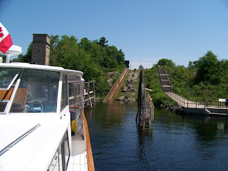
On Monday June 25, we pulled anchor and went the last 4 miles to Lock 44, called "Big Chute". As you can see, this lock is actually a cart that goes up and over, a net drop of 59'. This system was developed to keep the migration of the parasitic sea lamprey from infesting the Lake Simcoe fishery. For you crane guys reading this blog, Hepburn built the cart, ABB built the winch and adjustable frequency control, and Motorola supplied the radio control which operated from the cart. The winch imployes "single failure proof" design. Here's how it works;


Boat drives on, boat comes out and over the top restained in straps.

Down the back Into the lower side water


Large SeaRay going over ahead of us


On we go, over the top, down the back side


Back in the water on our way at the lower level

After passing through one more lock, we were in Georgian Bay. What a fascinating canal system.

Monday, June 4, 2007

Side trip down the St. Lawrence

After attending a church service at a beautiful old Presbyterian Church in Sackets Harbor on Sunday morning, we proceeded north to the St. Lawrence River. Severe thunderstorm warnings were issued about 3:00 pm so we started thinking about a place to spend the night. We went in behind a breakwater at Cape Vincent and spent the night at their town dock.

Monday morning, June 4, we bicycled around town, met the volunteers at the Chamber of Commerce and Tibbetts Lighthouse only to leartn they both spend several months on Fripp Island every spring. It's a small world! We left about noon and proceeded down the St. Lawrence River and stopped at Heart Island where Boldt Castle is. George C. Boldt, millionaire proprietor of the Waldorf Astoria Hotel in New York City, set out to build a full sized Rhineland Castle for his wife. His wife died at the age of 42 and George never finished the castle. The structure stood empty from 1904 until 1977 when the Thousand Island Bridge Authority assumed ownership and is restoring the magnificent structures for the enjoyment of the present and future generations. Included as part of this site is the Boldt Yacht House a very large boat house with four slips under roof that are 128' long with the center bay being 64' high to house the family steam powered yacht. If your interested in more details go to www.boldtcastle.com.

Monday night was spent at the town dock in Alexandria Bay, NY. Tuesday we checked into Canadian Customs at Rockport, Ontario and had a beautiful ride to Kingston through the Canadian Thousand Islands.

Saturday, June 2, 2007

North onto Lake Ontario

On Tuesday May, 29 we left Seneca Falls and back tracked on the Erie Canal until it joined the Oswego Canal. We went as far north as Phoenix, NY where we spent the night at the city dock with free water and power. On Wednesday we went the last 21 miles to Oswego, NY where we had a scheduled lay over to change oil and reprovision before heading across Lake Ontario. On Friday we left about noon, after visiting Fort Ontario, to head out to the NE in fog towards Sackets Harbor. About 2 hours out I noticed that the oil pressure in the starboard engine was low. Shut it down, went below to find that oil was leaking from the oil filter. Continued the trip up to Henderson Bay on the port engine. Anchored for the night in Henderson Bay. Today, Saturday June 2, we came the reast of the way to Sackets Harbor where we are at Navy Point Marina. We have fixed the oil leak and spent several hours this afternoon viewing Fort Thomkins and Sackets Harbor Battlefield. This was the first site for the US Navy while we were tring to defind ourselves from the British in the War or 1812. The British were invading from Kingston, Ontario which is just to the north on the other side of the St. Lawrence River. It will be interesting to see the forts in Kingston and get the Canadian side of the story. There is lots of history in this part of the country. We will leave tomorrow an head up to the Thousand Islands for a couple of days before we enter Canada.

Monday, May 28, 2007

Side Trip to Seneca Lake


After leaving Brewerton on Saturday, May 26, we continued west on the Erie, instead of turning north on the Oswego Canal. As we go through the next few locks we are climbing again. Further west we turn south on the Cayuga and Seneca Canal, go through one lock and then turn west towards Senica Falls, went through a double lock, and arrived in Senica Falls where we spend the night tied up to the town wall where they have free overnight stay with complementary power and water.


Double lock on Cayuga & Seneca Canal open for us to enter.

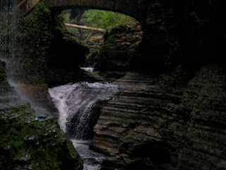
On Sunday we continued west on the canal through one more lock and entered the north end of Senica Lake. The run down the lake is 26 miles, we put the boat up on a plane and arrived in Watkins Glen at about 2:30 pm. We deployed the bikes and rode to Watkins Glen State Park to see the spectacular waterfall which has cut a gully 400' deep and two miles long during the last 12,000 years. The water that goes over this falls, dumps into Seneca Lake, which dumps into the Cayuga and Seneca Canal, which dumps into the Erie Canal, which dumps into the Oswego Canal, which dumps into Lake Ontario, which dumps into the St. Lawrence River, which dumps into the Atlantic. This process takes 25 years from the time the water flows down the falls in Watkins Glen.


The falls at Watkins Glen State Park, it's impossible to capture what we saw on film!


Looking north up Seneca Lake from Looking south towards Watkins Glen
Watkins Glen. from about 8 miles up the lake.

Today, Monday, May 28 we are again on the town wall at Senica Falls. Waterloo, NY is only 3 miles to the west and it was at Waterloo that Memorial Day was first declaired, this was a pretty happining place this weekend. Tonight however there are only three boats that will spend the night.

ODYSSEE sitting at the wall in Seneca Falls.

Tomorrow we proceed back east to the Oswego Canal on our way up to Lake Ontario.

Tuesday, May 22, 2007

West on the Erie

We got to Waterford, NY, the entrance to the Erie only to learn that the canal was closed at Lock 18 until the middle of this week, that is tomorrow. We arrived at Waterford on Thursday, May 17, tied up to the Visitors Center floating dock, where they offer two nights free dockage including power and water. Every night after two is $10.00 a night. What a bargin! We stayed 3 nights, gave them $20.00, $10.00 for the third night and a $10.00 donation.

On Sunday we moved up to the Cresent Boat Club, and met with a retired police officer who had a canvas shop in his garage, to do some minor repair on some tabs on our starboard side curtains. We actually did the repair work until 9:30 PM Sunday night, and they reinstalled the side curtains on Monday morning. We were plugged in with power and water so Claria did some laundry in our washer/dryer on the boat. We left a about 2:00 PM and motored west on the canal to Amstgerdam, where we tied up to the town park wall. We plugged in for the night, but couldn't find anybody to pay and the phone numbers in the cruising guide didn't work. There were three of us there for the night, and we all said "Thank You", and left.

Today, Tuesday May 22, we traveled further west, and are anchored just below lock 16 for the night. There are quite a few boats that have bunched up here, at local marinas, tied up to the lock walls, or anchored out. Weather was beautiful today, the scenery on the canal is beautiful as we go through the mountains in the Mowhawk River valley which makes up the Erie in this part. We have traveled west in the canal 71 miles, probably about 45 miles as the crow flies, gone through 14 locks, and are currently 322' above sea level. When we get to lock 17 we go up 42' in one lock, that ought to be interesting.

This corridor through the mountains has railroad tracks on the north side of the canal and Interstate 90 on the south side of the canal. At one point we had an east bound and west bound train passing each other at some 60 MPH each, looked south to see traffic going east and west, looked up to see contrails of planes going east and west, as we motored along at 9 mph. What a great way to travel!


View looking west as we motor along!

Friday, May 25, and we are tied up to the canal wall in Brewerton, NY, at the west end of Oneida Lake. On Wednesday we moved up to the lower wall of lock 17, in Little Falls, NY, a very friendly little town. The Canal finally opened up on Thursday at noon and we were among the first four boats to go up 42' in the first lock through at about 12:30. Two notable boats were with us, the first a 90' Burger, TO FOUR owned by on of the Fisher family of General Motors which was being moved by it's crew from Florida to Michigan for the summer. The other boat was Hunter's Child II, a 50' version of Hunter's Child that Steve Pettengill solo raced around the world. Steve was on the boat and is moving it to the Great Lakes for some summer racing. We followed Hunters Child II through the next few locks. As we came out of lock 19 there was a shallow area at the upper end of the lock, and as Hunter's Child II tried to pass through with their 8' draft they got stuck. They backed off and tried again only to hit bottom again. So Steve radioed us and asked if we could try to pull him through. So we maqde up a bridle and he tied on a bow line. He hit again, and at idle speed on ODYSSEE we brock his bow line. It snapped back and under our boat, and you guessed it got around our port prop. We are right in the channel of the lock exit. Claria took the weel, radioed the lock master who was bringing up the next load, to tell him of our situation and advised him to hold the opening of the lock until we had the rope cleared. I set an anchor, put on my dive gear, took my shearing knife, and went under the boat to cut the rope clear. Well the lock mast didn't hold the opening of the lock and there were some very impatient Carvers and SeaRays in this load who wanted to go, irrespective of the fact that I was still in the water. All the radio discussion had been on channel 13, so all those boaters were aware of the situation. It only took me about 10 minutes to clear the prop, but we still had an anchor to pull, and these boaters were furious and rude, and were passing us with close clearance. Claria was furious, requested that they let me reboard the boat before passing to no avail. Luckily nobody got hurt and no contact was made between boats, but these jerks were just stupid. Thats probably why they have Carvers and SeaRays! Two boats did hold back of the six that were in that lock load, a Grand Banks and a Canadian trawler. When we got to the next lock, that lock tender held the rude boaters in the lock until we got there and then locked us up, so in all their hast, they didn't gain any ground. That lock tender came to talk to us as did the Canadian trawler owner, thanking us for trying to help Hunter's Child II. When we arrived here this afternoon, another Canadian boat owner who had heard the whole thing on the radio, came over to grab our lines and to pass on their appreciation of what we had done. We now have some new friends from Montreal.

Last night we spent the night on the wall at Rome, NY. This morning we went to Fort Stanwix, the fort the British put up to protect the water route. Near Rome are head waters of the Mohawk river to the east and Wood Creek to the west that are the natural waterways that are used to form the Erie Canal. This is truly an interesting waterway that was an important thorofare in history.

Saturday, May 19, 2007

Trip up the Hudson

It's Saturday, May 19. We're sitting at the welcome center part at Waterford, NY, waiting for the Erie Canal to open. It was closed to boat traffic last week so a break in the wall at lock 18 can be repaired. Lock 18 is 84 miles to the west of this location, a two day run from here, We expect the canal to open again on Wednesday. Tomorrow we are going to go about 10 miles west to Cresent Boat Club where we will meet a canvas man to do some repair work on our rear side curtains.


We had a great ride up the beautiful Hudson River. Highlight of the trip was a guided tour of West Point arranged by my sister's neighbor. We also visited FDR's home and the Vanderbilt Mansion. Both are run by the National Park Service so our "golden age cards" got us free access. The downer for the week was having Alltel turn off our phone due to their error. We couldn't call out and nobody could call in, they were charging us air time for all the time we are on the internet or e-mail. Our plan has unlimited internet access but the Alltel billing computer doesn't know how to log the time we use on this fancy bag phone system. I'm not sure we've got it worked out yet, but Alltel thinks we are calling our message center, when we are actually on the internet during those minutes. They think we spent 309 minutes checking messages last month.


My sister has turned around and is heading back south towards St. Michael's

Saturday, May 12, 2007

The Trip

LOST THIS ENTIRE POST LAST NIGHT WHEN I TRIED UP UPDATE!!!!! AGAIN, I WILL FILL IN THE FIRST PART OF THE TRIP WHEN I CAN.

Saturday, May 12, we took our boat around Manhatten Island, a 32 mile trip up the Hudson River, east on the Harlem River, through Hells Gate, west on the east river, then back north up the Hudson River past the Statue of Liberty and Ellis Island back to our marina. Interesting trip. Tomorrow we will start up the Hudson River.